156
156
Dec 11, 2012
12/12
by
KCSMMHZ
tv
eye 156
favorite 0
quote 0
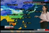
let's head on into the americas. central portions are looking calm and clear. a storm from the pacific, dropping down from b.c. to central california. chilly showers to post coastal areas. and we'll be seeing some snow, a few inches on the sierra nevadas and moving inland as well. strongest gusts bringing temperatures down in portions of southern california in the next couple of days. out toward the east, we've been watching a stubborn system move away out over the atlantic, but what will be left over is heavy showers in the eastern gulf states as well as in the florida peninsula and you can see some severe thunderstorms erupting there too. here are temperatures. a big drop out in the northeast. new york city, 9 degrees today. 9 in d.c. a drop of 10 degrees between monday and tuesday. further up toward the north. that's your high temperature. winnipeg, minus 20. high temperature, even down to houston, 13 for the high. but overnight lows will be around the freezing point. as for europe, not too much to worry about for western and central locations. potent low br
let's head on into the americas. central portions are looking calm and clear. a storm from the pacific, dropping down from b.c. to central california. chilly showers to post coastal areas. and we'll be seeing some snow, a few inches on the sierra nevadas and moving inland as well. strongest gusts bringing temperatures down in portions of southern california in the next couple of days. out toward the east, we've been watching a stubborn system move away out over the atlantic, but what will be...
204
204
Dec 20, 2012
12/12
by
KCSMMHZ
tv
eye 204
favorite 0
quote 0
now let's take a look to the meshgz a americas. you can see on the satellite picture that comma shape popping up here. that's indicating very strong, rather potent system attached to it. this cold front already producing several tornado warnings across this area, especially over towards alabama. we're watching this system work its way towards the east. that's going to be bringing some more severe weather around portions of the carolinas, even into georgia. north of that, seeing some rain. but then once you get into the appalachians, that is changing over to heavy snow. even in organizatiportions of t lakes, cold air pushing from the north. that will bring the lake-effect snow machine on tap for you going into your weekend especially. mean while, let's take a look at the other side of the country here into the western u.s., even western canada. a pacific storm system is pushing on shore here. gusty winds even in northern california and higher elevations, you could be seeing upwards of hun h00 centimeters snowfall. that continues to
now let's take a look to the meshgz a americas. you can see on the satellite picture that comma shape popping up here. that's indicating very strong, rather potent system attached to it. this cold front already producing several tornado warnings across this area, especially over towards alabama. we're watching this system work its way towards the east. that's going to be bringing some more severe weather around portions of the carolinas, even into georgia. north of that, seeing some rain. but...
171
171
Dec 27, 2012
12/12
by
KCSMMHZ
tv
eye 171
favorite 0
quote 0
as we take a look over towards the americas, we have been watching this storm system push across the eastern u.s., now off towards new england. still have blizzard warnings in effect into maine extending out there towards the west and also dealing with that lake-effect snow, that cold air wrapping around this low-pressure system into ontario, lake ontario here, over towards lake erie, the southern portions is where you've been seeing very heavy snowfall. not to mention gusty winds continuing to occur all across this region. so blizzard conditions, whiteouts on the roads. if you do not have to drive, i'd recommend staying inside and riding this one out because that's going to be some very dangerous traveling conditions, not to mention airport delays and cancellations across much of this region. behind it conditions really clearing out here. chicago just above the freezing mark for your high on your thursday but it is expected to be sunny skies. same over there into denver, minus 3 for your high. down towards the south, houston, you're starting to warm up from yesterday's high right ar
as we take a look over towards the americas, we have been watching this storm system push across the eastern u.s., now off towards new england. still have blizzard warnings in effect into maine extending out there towards the west and also dealing with that lake-effect snow, that cold air wrapping around this low-pressure system into ontario, lake ontario here, over towards lake erie, the southern portions is where you've been seeing very heavy snowfall. not to mention gusty winds continuing to...
152
152
Dec 10, 2012
12/12
by
KCSMMHZ
tv
eye 152
favorite 0
quote 0
to the americas, you are just getting a smashing of snow over the northern rockies, not too much going on through central and northern portions of the continent. a frontal system moves further toward the atlantic. let's show you what happened when the front moved through. video of the wisconsin. as it moved across the dakotas and great lakes region, plows out in full force in wisconsin. traffic obviously crawling there due to slick roads, but skiers and snowboarders took to the slopes for the first time this year after the winter storm dumped plenty of fresh powder. not everyone was enjoying the snow, however, and there were more than 20 car crashes reported across minnesota. as a result of the early season storm. most of them stuck in ditches or in snow banks. now, after that cold front passes, temperatures are really going to be falling across much of the east. let's show you some of the figures. in chicago, you are down to 2 degrees for your high. 4 degrees in oklahoma city. 11 in houston. tuesday, you will see 1 degree for the low in houston. right down to the south, seeing tempera
to the americas, you are just getting a smashing of snow over the northern rockies, not too much going on through central and northern portions of the continent. a frontal system moves further toward the atlantic. let's show you what happened when the front moved through. video of the wisconsin. as it moved across the dakotas and great lakes region, plows out in full force in wisconsin. traffic obviously crawling there due to slick roads, but skiers and snowboarders took to the slopes for the...
215
215
Dec 18, 2012
12/12
by
KCSMMHZ
tv
eye 215
favorite 0
quote 0
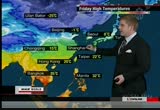
as we look over towards the americas, we continue to watch a series of storm systems here into the west. that has been bringing already some gusty winds actually in utah here. you saw 153-kilometer-per-hour winds day. it will push off in the next 24 hours and bring in gusty winds and this heaviy snowfall. 20 centimeters anywhere in the black. some isolated areas into higher elevations could keep upwards of 60 centimeters of snowfall. not just here but a separate storm system pushing onshore in british columbia. that will bring heavy snowfall for you. this one not just affecting this area. as we look into the next several days, it is going to be cruising out over the central plains bringing with it some blizzard-like conditions and winds gusting around 50 to 60 kilometers per hour reducing visibility with the blowing snow mixed in there. eventually off towards the great lakes into the northeast. anybody who has travel plans across any major cities in this region going slew thursday and friday and even into the weekend. you're going to want to check in on this ahead of time, especially if
as we look over towards the americas, we continue to watch a series of storm systems here into the west. that has been bringing already some gusty winds actually in utah here. you saw 153-kilometer-per-hour winds day. it will push off in the next 24 hours and bring in gusty winds and this heaviy snowfall. 20 centimeters anywhere in the black. some isolated areas into higher elevations could keep upwards of 60 centimeters of snowfall. not just here but a separate storm system pushing onshore in...
134
134
Dec 17, 2012
12/12
by
KCSMMHZ
tv
eye 134
favorite 0
quote 0
also talking about cold air and snow is into the pacific northwest and into north america where we have plenty of snow showers here and over idaho and montana. much of the northern rockies could be seeing 30 to 60 centimeters not to mention the winds gusting near 100 kilome r kilometers an hour. all the lines close together indicates the strong wind gusts and blizzard warnings. very messy situation. also we're seeing messy weather into the ohio river valley pushing to into the northeast. new england, you're expecting freezing rain, five to ten millimeters going into your tuesday. this just continues to push here. definitely a very serious situation as far as driving across these areas. make for some very slippery roads. do slow down across this region. fen even if you have flights, there could be delays. new york, your temperature is 9 degrees on this monday. chicago, you've been going for a while without snowfall. the last snow has been in march. still, seeing some cold temperatures though over chicago. high of 5. winnipeg at minus 9 here. starting off your work week. now as we look to
also talking about cold air and snow is into the pacific northwest and into north america where we have plenty of snow showers here and over idaho and montana. much of the northern rockies could be seeing 30 to 60 centimeters not to mention the winds gusting near 100 kilome r kilometers an hour. all the lines close together indicates the strong wind gusts and blizzard warnings. very messy situation. also we're seeing messy weather into the ohio river valley pushing to into the northeast. new...
151
151
Dec 6, 2012
12/12
by
KCSMMHZ
tv
eye 151
favorite 0
quote 0
let's take a look over towards the americas where a frontal area is pushing across the western great lakes here, continuing to push towards the east. this is bringing some snowfall for you, as well, southern ontario, a mix of rain and snow. some freezing rain is going to be on tap for you as this continues to push off to the east. and south of the freezing line, though, you're seeing some rain showers moving across portions of the ohio river valley and eventually off towards the east. but as we look into the gulf coast, things remain nice for you, houston with a high of 34, oklahoma city, high tler, and 19 in los angeles with a high of 20. now, as we take a look over towards europe, several low-pressure systems continue to move in across the west here. this is bringing some snow showers for the most part. some rain is going to be seen across the southern portions of the uk, though. what this is going to be bringing is the risk of flooding. last week you saw very significant flooding here, and the ground is already stamp rated so you do not need any more rainfall coming across this ya
let's take a look over towards the americas where a frontal area is pushing across the western great lakes here, continuing to push towards the east. this is bringing some snowfall for you, as well, southern ontario, a mix of rain and snow. some freezing rain is going to be on tap for you as this continues to push off to the east. and south of the freezing line, though, you're seeing some rain showers moving across portions of the ohio river valley and eventually off towards the east. but as we...

 Live Music Archive
 Librivox Free Audio
 Metropolitan Museum
 Cleveland Museum of Art
 Internet Arcade
 Console Living Room
 Books to Borrow
 Open Library
 TV News
 Understanding 9/11